Reading time: 18–22 minutes | Last updated: April 2026
Table of Contents
- The Story Behind the Abuja Master Plan Blueprint
- What Is the Abuja Master Plan?
- Who Designed It — and Why That Matters
- The Core Principles Governing Abuja’s Layout
- The Districts of Abuja: A Complete Breakdown
- The Central Business District Explained
- The Satellite Towns: The Often-Overlooked Opportunity
- How the Abuja Master Plan Controls Land Use
- What the Abuja Master Plan Means for Investors Today
- Common Mistakes Buyers Make When They Ignore the Plan
- Nik de Panache’s Perspective: Where the Real Opportunity Lies
- Frequently Asked Questions
- Published References
1. The Story Behind The Abuja Master Plan Blueprint
By 1975, Lagos was a city choking on its own success.
Traffic moved like concrete. Infrastructure was stretched far beyond its original design. And sitting on a thin strip of Atlantic coastline in the far southwest of a country with 250 ethnic groups and 36 states, it was increasingly clear to Nigeria’s military leadership that the commercial capital could no longer carry the additional weight of being the nation’s political centre.
The problems with Lagos were not simply logistical. They were existential. Its geography — coastal, peripheral, predominantly Yoruba — made it a capital that could never truly belong to the whole country. The north felt distant from it. The east resented it. And the city itself was collapsing under the strain of being everything to everyone.
On August 9, 1975, the Federal Military Government under General Murtala Mohammed set up a panel, chaired by Justice Akinola Aguda, to answer a simple question: should Lagos remain Nigeria’s capital? [1] The panel toured the country, studied world capitals including Brasília, Islamabad, Paris, and Washington D.C., and came back with a firm recommendation: move the capital. [2]
The location they chose sat at the geographic centre of Nigeria — a high plateau of savannah grassland carved from parts of Niger, old Kwara, and old Plateau states, surrounded by ethnic groups — the Gbagyi, Koro, Gade, Gwandara — that belonged to none of Nigeria’s dominant nationalities. [3] It was, in the most literal sense, neutral ground.
On February 3, 1976, General Murtala Mohammed promulgated Decree No. 6, officially establishing the Federal Capital Territory and creating the Federal Capital Development Authority (FCDA) to oversee its development. [4] The FCT covered approximately 8,000 square kilometres. The city that would be built within it was given a name: Abuja.
What followed was one of the most ambitious planned city projects in African history. And the document that governed every square metre of it — that still governs what you can build, where, and how high — is the Abuja Master Plan.
2. What Is the Abuja Master Plan?
The Abuja Master Plan is the official urban development blueprint for Nigeria’s Federal Capital Territory. Submitted to the FCDA on February 15, 1979 [5], it is a comprehensive framework that defines:
- The layout and boundaries of every district, zone, and sector in the Federal Capital City
- The permitted land use for every category of plot
- The phased development sequence, from the inner core outward
- The infrastructure spine: roads, utilities, green corridors, and institutional zones
- The character and function of every major district
- The population targets and density controls for each zone
The Federal Capital City (FCC) — the planned urban area within the broader FCT — covers approximately 250 square kilometres, while the five phases of planned development collectively span about 1,000 square kilometres. [6]
Think of the Abuja master plan as the legal constitution of Abuja’s physical form. Just as a constitution establishes the rules every citizen must operate within, the Master Plan establishes the rules every developer, landowner, and investor must operate within. Violate it, and the consequences are not theoretical — they are enforced.
For property investors, this matters enormously. Where a plot sits within the Master Plan hierarchy directly determines its permitted uses, its development ceiling, and ultimately, its market value. The Master Plan is not just a planning document. It is a valuation document.
3. Who Designed The Abuja Master Plan — and Why That Matters
The Abuja Master Plan was designed by International Planning Associates (IPA), a consortium of three American firms that came together specifically to win the FCDA’s worldwide competitive bid. [7] The three firms were:
- Planning Research Corporation (PRC) — urban planning and systems analysis
- Wallace, McHarg, Roberts and Todd — landscape architecture and ecological planning
- Archisystems — a division of the Hughes Organisation, handling architectural design
IPA did not exist before this commission and was disbanded after completing the project. [8] The FCDA commissioned them in June 1977, and 18 months of work followed — covering site data review, regional planning, city planning, and the preparation of a design and development standards manual. [9] The final report was submitted to the pioneer Executive Secretary of the FCDA, Alhaji Abubakar Koko, on February 15, 1979. [10]
In the preface to that report, IPA wrote:
“The master plan for Abuja, the new Capital City of Nigeria, represents the culmination of 18 months’ work by the Federal Capital Development Authority (FCDA) board, several advisory panels and consultants. Without the unstinting efforts of these experts, the momentum now exhibited at the beginning of the actual implementation of the new capital could not have been achieved.” [11]
It is worth noting that IPA’s lead ecological firm — Wallace, McHarg, Roberts and Todd — brought a specific philosophical approach to the design. Rather than imposing a grid on the landscape, they worked with the natural topography: the ridges, drainage channels, and rock formations of the Abuja plateau were treated as structural elements, not obstacles. This is why Abuja’s road network follows natural ridge lines, why green corridors track drainage patterns, and why Aso Rock — that 400-metre granite monolith — was preserved as the city’s defining visual anchor. [12]
The monumental core and Central Business District received a further layer of detailed design from Japanese architect Kenzo Tange, who won a competition in 1979 to design the central area. His blueprints incorporated the macro-elements of Wallace Roberts and Todd’s original plan while adding structures inspired by Brasília and Chandigarh. [13] The final detailed urban design for the Central Area was presented to the FCDA on April 30, 1981. [14]
The result was what architectural historian Nnamdi Elleh has described as a unique fusion: a modernist array of boldly geometric structures planted on a baroque urban layout — two architectural visions merged into one city. [15]
Why does the Abuja master plan matter to investors?
Because the city was not designed to be dense. It was designed to be expansive — low-rise across most zones, with significant green space built into its structure. This creates permanent scarcity in the high-value central zones. There is a finite amount of land that will ever receive permission for high-density commercial or residential development. Scarcity plus infrastructure plus institutional demand equals durable long-term value.
4. The Core Principles Governing Abuja’s Layout
Before breaking down the districts, it helps to understand the principles embedded in the Abuja Master Plan, because they explain why certain locations command the prices they do, and why that logic is not arbitrary.
Geographic neutrality as a founding principle. Abuja was specifically chosen because it lay in terrain occupied by ethnic groups — the Gbagyi, Ganagana, Basa, and Gwandara — that belonged to none of Nigeria’s dominant nationality groups. [16] This neutrality was not incidental. It was the primary political justification for the city’s existence. It shaped where the capital was placed, and it shapes how the capital continues to function.
Phased, concentric development. The Federal Capital City was divided into phases that expand concentrically outward from the foot of Aso Rock. Phase 1 forms the inner core. Each subsequent phase represents a ring of expansion. Development was intended to proceed phase by phase, ensuring that infrastructure preceded population. [17] This sequencing — and the premium it creates for established phases — remains operative today.
Hierarchical zoning. Land use follows a clear hierarchy: institutional and national at the highest level, then commercial, then high-density residential, medium-density residential, and low-density residential. Each zone within each district has a designated use that determines what can be built on it. This hierarchy is the foundation of the Master Plan’s role as a valuation instrument.
The neighbourhood unit model. Within residential districts, the Master Plan prescribes self-contained neighbourhood units — housing clusters supported by schools, local shops, clinics, and parks within walking distance. [18] This is why Abuja was designed to feel different from Lagos: it was assembled from deliberate modules rather than allowed to sprawl organically.
The green framework. Out of the FCT’s approximately 800,000 hectares, significant land was reserved for purposes other than urban development: 274,000 hectares earmarked for agricultural development, 270,000 hectares for forest reserves, and 60,000 hectares for natural resources including rivers and hills. [19] This permanent green framework is why certain land in the FCT will never — regardless of demand — be released for development.
5. The Districts of Abuja: A Complete Breakdown
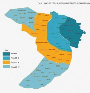
The Federal Capital City is organised into five phases. Here is a verified breakdown of each phase and its key districts.
Phase 1: The Central Core
Phase 1 of the Abuja master plan
is the original nucleus — the area developed first, carrying the city’s highest land values and most prestigious addresses. It spreads outward from the foot of Aso Rock and contains nine districts: Asokoro, Central Area, Garki, Garki II, Guzape I, Guzape II, Maitama, Wuse, and Wuse II. [20]
These districts boast the city’s most mature infrastructure and house its most significant institutional, diplomatic, and governmental functions.
Maitama
Maitama sits to the north of the city centre, sharing borders with Mpape, Wuse, Katampe, and the Central Area. [21] It was designed as a high-class residential and diplomatic zone — and the city delivered on that vision. Today, it houses many of Nigeria’s embassies, top government buildings, and luxury homes, including the British High Commission along Aguiyi Ironsi Way. [22] Landmarks include Millennium Park, the Transcorp Hilton Hotel, the Nigerian Communications Commission (NCC), and the Independent National Electoral Commission (INEC). [23]
From an investment standpoint, Maitama is a capital preservation territory. It is low-density by design — large plots, restricted building heights, no commercial intrusion into residential zones. There is not much of it, and what exists commands prices that reflect both its character and the structural, permanent demand from embassies, diplomatic missions, and senior government officials.
Asokoro
Asokoro is described accurately as “the doyen of the districts.” [24] It houses virtually all of the state lodges and guesthouses, the Presidential Palace (Aso Rock), and the ECOWAS Secretariat. It is one of Abuja’s most exclusive districts, home to federal cabinet ministers and most of the city’s diplomatic community. By virtue of the Presidential complex, it is the most secure area in the city. [25]
Asokoro’s investment case requires little elaboration. Its proximity to power is literal. Its exclusivity is enforced by the same zoning controls that govern Maitama. Its values do not depreciate.
The Central Area (Central District)
The Central Area runs like a spine from Aso Rock in the east toward the National Stadium and Old City Gate in the west. [26] It divides Abuja into its northern sector (Maitama and Wuse) and southern sector (Garki and Asokoro). While each district has its own commercial and residential zones, the Central Area is the city’s principal business zone — where the Three Arms Zone is located, housing the executive, legislative, and judicial arms of the federal government. [27]
Garki
Garki sits in the southwest corner of the city, having the Central Area to its north and Asokoro to its east. [28] It is subdivided into areas (Areas 1 to 11), giving rise to a naming convention that confuses many newcomers to Abuja — Garki II is distinct from Garki Area 2. The district houses the Army, Navy, and Air Force Headquarters on Muhammadu Buhari Way, as well as the Abuja International Conference Centre, the Nicon Luxury Hotel, the Central Bank of Nigeria offices, and the FCDA and FCT Minister’s Office in Area 10. [29]
The Radio House in Area 11 — the tallest building in the district — houses the Federal Ministry of Information and Communications, the Federal Radio Corporation (FRCN), and the Voice of Nigeria (VON). [30] Garki is presently the principal business and administrative district of Abuja and presents a compelling mixed institutional-commercial investment case.
Wuse
Wuse is the northwestern part of the city, with Maitama to its north and the Central Area to its south. The district is numbered Zones 1 to 6. [31] It houses the Sheraton Hotel and Towers (Zone 4), the Federal Road Safety Corps Headquarters (Zone 3), the Nigerian Customs Services Headquarters, NAFDAC, and Wuse General Hospital. The Wuse Market is Abuja’s principal market and one of its busiest commercial nodes. [32]
Wuse II
Wuse II is distinct from Wuse Zone 2 — a point of persistent confusion. Like Asokoro and Maitama, it has very few large housing estates; instead, office buildings, mansions, and apartment blocks dominate. [33] Wuse II has emerged as one of Abuja’s most commercially active zones, attracting high-end retail, restaurants, and financial institutions.
Guzape
Guzape I and II round out Phase 1. Guzape has attracted significant investor attention in recent years, offering proximity to Phase 1’s core premium districts while still presenting development opportunities that the more established districts no longer offer. Its elevation gives it distinctive views and a character that differentiates it from the flatlands of outer phases.
Phase 2: The First Ring of Expansion
Phase 2 of the Abuja master plan
is described as a well-developed region with beautiful neighbourhoods, great infrastructure levels, and an extensive road network — closely comparable to Phase 1 in development and infrastructure quality. [34]
It contains 15 districts: Apo-Dutse, Dakibiyu, Duboyi, Durumi, Gaduwa, Gudu, Jabi, Jahi, Kado, Katampe, Kaura, Kukwaba, Mabushi, Utako, and Wuye. [35]
Jabi
Jabi has transformed from a mid-range residential area into one of Abuja’s most vibrant mixed-use zones, anchored by the Jabi Lake development — a man-made lake surrounded by a mall, hotels, and waterfront residences. For investors looking at commercial real estate, hospitality, or short-let residential, Jabi presents a compelling case at the intersection of leisure and professional demand.
Utako
Utako is one of Abuja’s most commercially dense zones outside the CBD and Wuse II, housing car dealerships, furniture showrooms, and a dense concentration of retail. Its commercial character makes it relevant for investors in commercial property and warehousing.
Mabushi
Mabushi’s position on the corridor between the central districts and the airport has made it strategically significant for hospitality and business accommodation — a natural location for hotels and serviced apartment complexes serving the transit business market.
Katampe, Kado, Wuye
These Phase 2 districts have attracted significant residential investment from civil servants and professionals seeking Phase 1-adjacent quality at more accessible price points. Katampe’s elevation, Kado’s planned estate infrastructure, and Wuye’s mixed-use dynamism each present distinct propositions.
Phase 3: The Outer Ring
Phase 3 of the Abuja master plan is located further from the city centre and is described as relatively affordable, with decent public infrastructure levels and accessible road networks, though some districts are still undergoing development. [36]
It contains approximately 17 districts, including: Bunkoro, Dakwo, Dape, Dei-Dei, Gishiri, Kabusa, Karimo, Karshi, Life Camp, Lokogoma, Nbora, Orozo, Pyakasa, Tsafe, Wasa, Gwarinpa, and Gwagwa. [37]
Gwarinpa
Gwarinpa is notable as one of the largest housing estates in West Africa by plot count. It was developed partly as a government housing initiative and has matured into a substantial residential community with its own commercial character.
Life Camp
Life Camp has seen rapid apartment and terrace house development targeting the salaried professional market. Its relative proximity to Phase 2 and improving road connections have driven consistent demand.
The Suburban Districts
The Master Plan recognises several suburban districts that were not originally part of its five phases but have grown due to their proximity to the planned city: Kubwa, Nyanya, Karu, Kuje, Jikwoyi, Mpape, and Dawaki. [38] These areas have developed rapidly as population pressure has pushed outward from the core phases.
Phase 4 and Phase 5: The Future Frontier
Phase 4 of the Abuja master plan is largely undeveloped, with much of the land still vacant, though it is expected to undergo substantial development as Abuja expands. [39]
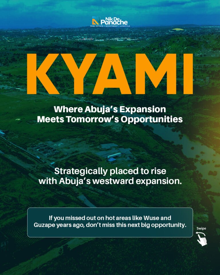
Phase 5 of the Abuja master plan covers the area near the Nnamdi Azikiwe International Airport and the University of Abuja’s permanent campus — the Kyami District — over 40 kilometres west of Aso Rock. [40] This phase is associated with airport-related development: hotels, business centres, and educational facilities.
For investors, Phase 4 and 5 positions are speculative and require long time horizons. The Master Plan does designate these areas for eventual development — but implementation is contingent on government infrastructure investment, and timelines in Nigeria’s public sector have historically been optimistic.
6. The Central Business District Explained
The Central Business District deserves dedicated attention. It was designed by Kenzo Tange [41] and represents the most architecturally and economically significant zone in the Master Plan.
The Abuja Central Area plan — including proposals for a National Mall, National Theatre, National Library, hotels, and major commercial uses — was presented to the FCDA on April 30, 1981. [42] The vision was ambitious: a CBD to compete with world-renowned business centres, planned for big private and multinational investment rather than small or medium-scale development. [43]
The Central District is where practically all parastatals and multinational corporations have their offices. [44] It is the city’s principal business zone, connected to the Three Arms Zone and the government complex that anchors Abuja’s institutional identity.
The CBD is one of the few zones in Abuja where significant building height has historically been permitted — creating, alongside its deliberate exclusivity, a genuine scarcity of Grade A commercial space that supports rental premiums. For commercial real estate investors, understanding the CBD’s planned character is essential context for evaluating any significant office or hospitality investment in central Abuja.
7. The Satellite Towns: The Often-Overlooked Opportunity
Beyond the five phases of the Federal Capital City, the FCT encompasses six Area Councils, each with its own administrative towns. These are not afterthoughts — they represent a planned outer ring of communities intended to serve the broader FCT population.
The key satellite and suburban towns include:
- Kubwa — the largest suburban district, developed originally as a dormitory town for government workers, now a city in its own right with its own commercial character
- Gwagwalada — a major area council headquarters with its own institutional and commercial ecosystem
- Kuje — positioned for agricultural and light industrial activity, with increasing investor interest
- Nyanya and Karu — one of Abuja’s densest residential corridors on the eastern edge, housing hundreds of thousands of civil servants and workers
- Lugbe — on the airport road corridor, benefiting from airport-driven hospitality, logistics, and residential demand
- Mpape — a fast-growing suburban area north of Maitama, adjacent to the new Maitama II District (Cadastral Zone A10) created by the FCT Administration in 2018 [45]
The investment logic of the satellite towns is straightforward: as the core city becomes more expensive and more congested, population pressure moves outward into these planned or organically grown communities. Infrastructure investment in these areas — whether government-driven or private — tends to unlock rapid value appreciation.
8. How the Abuja Master Plan Controls Land Use
The Abuja Master Plan is not passive documentation. It is an actively enforced legal framework with real financial and physical consequences for non-compliance.
The Certificate of Occupancy (C of O)
All land within the FCT is vested absolutely in the Federal Government of Nigeria, a principle established by the FCT Act of 1976 and reinforced by the Land Use Act of 1978. [46] What individuals and companies hold is a Right of Occupancy, evidenced by a Certificate of Occupancy (C of O) issued by the FCT Administration.
As recently as November 2025, FCT Minister Nyesom Wike granted property owners in Asokoro, Maitama, Garki, and Wuse a final 14-day grace period to pay a ₦5 million violation fee for breaching approved land use terms — specifically for converting properties to uses not authorised by their Right of Occupancy without official approval. [47] The FCTA simultaneously approved the issuance of new title documents with a fresh 99-year term upon full payment and compliance. [48]
This is not a historical anecdote. It is a live illustration — from 2025 — of the Master Plan’s enforcement teeth. The FCT Administration’s commitment to enforcing the Abuja master plan and ensuring compliance with land administration regulations is not rhetorical. [49]
Development Control
The Development Control Department of the FCDA is responsible for enforcing the Abuja Master Plan compliance — approving building plans, conducting site inspections, and demolishing structures built without approval or outside permitted parameters.
Tens of thousands of people were evicted beginning in 2003 when then-FCT Minister Nasir Ahmad el-Rufai initiated a large-scale demolition campaign against illegal structures. [50] The evictions affected businesses, apartment buildings, informal settlements, mosques, churches, schools, and even government buildings — including, in one case, an eviction notice placed on the Federal High Court itself, because the Master Plan had not envisioned a court in a residential area. [51]
The lesson is unambiguous: The Abuja Master Plan is not a suggestion.
The Right of Occupancy Tenure
New title documents issued under the current administration reflect a fresh 99-year term, confirming that the Right of Occupancy framework — under which government remains the ultimate land owner, and individuals hold use rights — remains the operative tenure model for all FCT property. [52]
9. What the Abuja Master Plan Means for Investors Today
Understanding the The Abuja Master Plan is not an academic exercise — it has direct, measurable implications for investment decisions.
Phase location determines baseline value. A plot in Phase 1 will always command a premium over a structurally equivalent plot in Phase 3, because Phase 1 has the infrastructure, the institutional anchors, and the established demand. This premium is structural — it is baked into the Master Plan’s logic and will persist.
Zoning determines development upside. A low-density residential plot in Maitama generates value through land appreciation and luxury residential use. A commercial plot in Garki or Wuse II may generate more income through mixed development. The permitted development ceiling of any plot tells you what your exit options are — which is why zoning verification must precede any purchase.
Documentation is the foundation of ownership. The Master Plan’s legal framework means that a C of O consistent with cadastral zoning records is the only document that gives you genuinely secure title. Recent enforcement actions in 2025 confirm that even long-held properties can face compliance action if they were developed outside approved land use terms. [53]
Phase transitions are where wealth is built. The greatest returns in Abuja real estate have come from investors who positioned in Phase 2 areas before Phase 1 was fully priced in, or in Phase 3 areas before infrastructure arrived. Identifying where the next phase transition is happening requires reading where government infrastructure investment is moving — and the Master Plan gives you the map.
The satellite towns are structurally undervalued. Land in Kubwa, Kuje, Mpape, and Bwari can still be acquired at prices that do not yet reflect long-term infrastructure improvement trajectories. These areas are not outside the FCT’s planning framework — they are part of it.
10. Common Mistakes Buyers Make When They Ignore the Abuja Master Plan
Buying on location name without verifying cadastral zone. “Maitama” is a premium address — but not every plot marketed as Maitama sits within the actual Maitama low-density cadastral zone. Always verify the cadastral zone reference against FCDA records.
Accepting verbal assurances about zoning changes. Zoning changes require formal FCDA action. Sellers or agents who claim a plot’s zoning “will be changed” to a more valuable designation are, without formal documentation, offering you nothing enforceable.
Developing beyond permitted use. Building a commercial structure on a residential plot, or exceeding approved height, creates a property that may be unfinanceable, unsellable to sophisticated buyers, and subject to demolition. The 2025 enforcement actions in Maitama, Asokoro, Garki, and Wuse demonstrate this is not a remote risk. [54]
Not checking for government acquisitions. Some parcels within the FCT are subject to government acquisition orders — reserved for public use. Buying such a parcel means buying a dispute.
Underestimating infrastructure timelines in outer phases. Phase 3 and Phase 4 investments can make sense — but only with realistic expectations. What is projected to happen in five years has sometimes taken fifteen.
11. Nik de Panache’s Perspective: Where the Real Opportunity Lies
At Nik de Panache, we spend considerable time reading the Master Plan not as a regulatory constraint, but as a map of where value is being created — and where it has yet to be recognised.
Our view is that the Abuja Master Plan’s greatest gift to investors is not the Phase 1 prestige market, though that market has its place for capital preservation. The greatest opportunity lies in understanding the infrastructure frontier — the advancing edge of government investment in roads, power, water, and institutions — and positioning ahead of it.
We see compelling long-term fundamentals in the inner Phase 2 districts where values remain below their fundamental worth relative to proximity to Phase 1; along the airport corridor, where logistics, hospitality, and residential demand are structurally supported; and in select satellite town positions where land can still be acquired at entry-level prices with Master Plan-supported long-term upside.
We are equally clear about what sophisticated investors should avoid: unverified land in outer phases sold without proper FCT documentation, properties whose development exceeds their zoning permissions, and plots whose sellers cannot produce a clean cadastral zone verification from the FCDA.
The Abuja Master Plan is, ultimately, a map of where value has been created, where it is being created, and where it will be created. Learning to read that map is the most valuable skill any Abuja real estate investor can develop.
12. Frequently Asked Questions
What is the Abuja Master Plan? The Abuja Master Plan is the official urban development blueprint for Nigeria’s Federal Capital Territory. Designed by International Planning Associates and submitted to the FCDA on February 15, 1979, it governs land use, zoning, district boundaries, and phased development of the capital city.
How many phases does the Abuja Master Plan have? Five phases. Phase 1 is the inner core (Maitama, Asokoro, Wuse, Garki, Central Area, Guzape). Phase 2 is the first ring of expansion (15 districts, including Jabi, Utako, Mabushi, Wuye). Phase 3 covers outer residential districts. Phase 4 is largely an undeveloped future territory. Phase 5 covers the airport vicinity, including Kyami and Lugbe.
Who controls the Abuja Master Plan? The Federal Capital Development Authority (FCDA), under the FCT Administration headed by a Minister appointed by the President of Nigeria.
What is a Certificate of Occupancy in Abuja? A Certificate of Occupancy (C of O) is the document evidencing a Right of Occupancy in the FCT. The Federal Government owns all land in the FCT. The C of O specifies the cadastral zone, plot number, permitted land use, development conditions, and tenure period (typically 99 years).
Can zoning designations be changed? Yes, but only through formal FCDA review processes. Verbal assurances from sellers about future zoning changes carry no legal weight.
Which districts have the highest property values? Consistently: Maitama, Asokoro, Guzape, and the Central Area for high-end residential and institutional. Wuse II and Garki for commercial and mixed-use. These are all Phase 1 districts.
What happens if I develop outside my permitted land use? As demonstrated by enforcement actions in November 2025, property owners who breach their Right of Occupancy conditions face a ₦5 million violation fee plus applicable conversion charges, and risk enforcement action by the FCT Administration if they do not comply.
13. Published References
The following are the verified sources used in the research and writing of this article on The Abuja master plan. Readers are encouraged to consult these primary and secondary sources directly.
[1] Federal Capital Development Authority (FCDA). The History of Abuja. FCDA official website. Available at: fcda.gov.ng/the-history-of-abuja
[2] Dubawa. (2020, October 1). Nigeria@60: Why Nigeria’s capital was moved from Lagos to Abuja. Available at: dubawa.org/nigeria60-why-nigerias-capital-was-moved-from-lagos-to-abuja/
[3] Wikipedia. Abuja. Available at: en.wikipedia.org/wiki/Abuja
[4] Explore Abuja. (2025, November 27). Abuja Master Plan (1979): All You Should Know About It. Available at: exploreabuja.ng/blog/abuja-master-plan/
[5] Daily Trust. (2020, March 16). Unsung Heroes of Abuja Master Plan. Available at: dailytrust.com/unsung-heroes-of-abuja-master-plan/
[6] Explore Abuja. (2025, November 27). Abuja Master Plan (1979): All You Should Know About It. Available at: exploreabuja.ng/blog/abuja-master-plan/
[7] Wikipedia. Abuja. Available at: en.wikipedia.org/wiki/Abuja
[8] Daily Trust. (2020, March 16). Unsung Heroes of Abuja Master Plan. Available at: dailytrust.com/unsung-heroes-of-abuja-master-plan/
[9] Wikipedia. Abubakar Koko. Available at: en.wikipedia.org/wiki/Abubakar_Koko
[10] Daily Trust. (2020, March 16). Unsung Heroes of Abuja Master Plan. Available at: dailytrust.com/unsung-heroes-of-abuja-master-plan/
[11] International Planning Associates. (1979). The Master Plan for Abuja, the New Federal Capital of Nigeria. Federal Capital Development Authority. Cited in: ReliefWeb / CHRE & SERAC. (2008). Nigeria: The Myth of the Abuja Master Plan. Available at: reliefweb.int/report/nigeria/nigeria-myth-abuja-master-plan
[12] Wikipedia. Abuja. (Aso Rock as city anchor.) Available at: en.wikipedia.org/wiki/Abuja
[13] CAA Reviews. Architecture and Politics in Nigeria: The Study of a Late Twentieth-Century Enlightenment-Inspired Modernism at Abuja, 1900–2016 (Review of Nnamdi Elleh’s work). Available at: caareviews.org/reviews/3371
[14] Daily Trust / Platform Times. (2025). The Abuja Central Area Plans and Realities (III). Available at: dailytrust.com/the-abuja-central-area-plans-and-realities-iii/
[15] CAA Reviews. Architecture and Politics in Nigeria. Available at: caareviews.org/reviews/3371
[16] Wikipedia. Abuja. (Indigenous ethnic groups.) Available at: en.wikipedia.org/wiki/Abuja
[17] Wikipedia. Abuja. (Phased development structure.) Available at: en.wikipedia.org/wiki/Abuja
[18] Oasdom. History of Abuja – How It Became Nigeria’s Capital. (Neighbourhood units of 150,000–250,000.) Available at: oasdom.com/history-of-abuja-how-it-was-created/
[19] FCT ACReSAL. The Federal Capital Territory (FCT). Available at: acresalfcta.org.ng/about-us/
[20] Explore Abuja. (2025). Abuja Phases & Master Plan: All You Need To Know. Available at: exploreabuja.ng/blog/abuja-phases/
[21] NaijaDetails. (2025, June 24). 10 Major Cities in Abuja’s Federal Capital Territory. Available at: naijadetails.com/major-cities-in-abujas-federal-capital-territory/
[22] Wikipedia. Abuja. (Maitama and British High Commission.) Available at: en.wikipedia.org/wiki/Abuja
[23] NaijaDetails. (2025). 10 Major Cities in Abuja’s FCT. Available at: naijadetails.com/major-cities-in-abujas-federal-capital-territory/
[24] Wikipedia. Abuja. (“The doyen of the districts.”) Available at: en.wikipedia.org/wiki/Abuja
[25] Wikipedia. Abuja. (Asokoro and Presidential Palace.) Available at: en.wikipedia.org/wiki/Abuja
[26] Wikipedia. Abuja. (Central Area description.) Available at: en.wikipedia.org/wiki/Abuja
[27] Wikipedia. Abuja. (Three Arms Zone.) Available at: en.wikipedia.org/wiki/Abuja
[28] Wikipedia. Abuja. (Garki District location.) Available at: en.wikipedia.org/wiki/Abuja
[29] NaijaDetails. (2025). 10 Major Cities in Abuja’s FCT. Available at: naijadetails.com/major-cities-in-abujas-federal-capital-territory/
[30] Wikipedia. Abuja. (Radio House, Garki.) Available at: en.wikipedia.org/wiki/Abuja
[31] Wikipedia. Abuja. (Wuse District Zones 1–6.) Available at: en.wikipedia.org/wiki/Abuja
[32] Wikipedia. Abuja. (Wuse institutions and Wuse Market.) Available at: en.wikipedia.org/wiki/Abuja
[33] Wikipedia. Abuja. (Wuse II character.) Available at: en.wikipedia.org/wiki/Abuja
[34] Explore Abuja. (2025). Abuja Phases & Master Plan. Available at: exploreabuja.ng/blog/abuja-phases/
[35] Explore Abuja. (2025, November 27). Abuja Master Plan (1979). (Phase 2 districts list.) Available at: exploreabuja.ng/blog/abuja-master-plan/
[36] Explore Abuja. (2025). Abuja Phases & Master Plan. (Phase 3 description.) Available at: exploreabuja.ng/blog/abuja-phases/
[37] Explore Abuja. (2025, November 27). Abuja Master Plan (1979). (Phase 3 districts.) Available at: exploreabuja.ng/blog/abuja-master-plan/
[38] Explore Abuja. (2025, November 27). Abuja Master Plan (1979). (Suburban districts outside phases.) Available at: exploreabuja.ng/blog/abuja-master-plan/
[39] Malik Sells Homes / Substack. (2024, September 16). Abuja’s Master Plan: The Vision for a Modern Capital City. Available at: maliksellshomes.substack.com/p/abujas-master-plan-the-vision-for
[40] Wikipedia. Abuja. (Phase 5, Kyami District.) Available at: en.wikipedia.org/wiki/Abuja
[41] Wikipedia. Abuja. (Kenzo Tange and the CBD.) Available at: en.wikipedia.org/wiki/Abuja
[42] Daily Trust. (2025). The Abuja Central Area Plans and Realities (III). Available at: dailytrust.com/the-abuja-central-area-plans-and-realities-iii/
[43] Platform Times. (2025, May 23). The Abuja Central Area Plans and Realities (III). Available at: platformtimes.com.ng/the-abuja-central-area-plans-and-realities-iii/
[44] Wikipedia / SOS Children’s Villages. Abuja. (Central District as principal business zone.) Available at: en.wikipedia.org/wiki/Abuja
[45] Wikipedia. Abuja. (Maitama II, Cadastral Zone A10, created 2018.) Available at: en.wikipedia.org/wiki/Abuja
[46] ResearchGate. Land Tenure System and Land Administration in the Federal Capital Territory (FCT), Abuja. Available at: researchgate.net/publication/362250384
[47] The Star / Leadership. (2025, November 9). Wike Grants 14-Day Ultimatum to Asokoro, Maitama, Garki, Wuse Land Defaulters. Available at: thestar.ng/wike-grants-14-day-ultimatum-to-asokoro-maitama-garki-wuse-land-defaulters-to-pay-n5m/
[48] Opinion Nigeria. (2025, November 10). Wike Gives Asokoro, Garki, Wuse, Maitama Property Defaulters Final 14 Days. Available at: opinionnigeria.com/wike-gives-asokoro-garki-wuse-maitama-property-defaulters-final-14-days-to-pay-n5m-land-use-violation-fee/
[49] Independent Newspaper Nigeria. (2025, November 9). FCT Reviewed Land Use: Wike Grants Asokoro, Garki, Wuse Defaulters Another 14 Days. Available at: independent.ng
[50] Wikipedia. Abuja. (El-Rufai demolition campaign, 2003.) Available at: en.wikipedia.org/wiki/Abuja
[51] ReliefWeb / CHRE & SERAC. (2008). Nigeria: The Myth of the Abuja Master Plan — Forced Eviction as Urban Planning in Abuja. Available at: reliefweb.int/report/nigeria/nigeria-myth-abuja-master-plan
[52] Opinion Nigeria. (2025). Wike Gives Property Defaulters Final 14 Days. (99-year term on new title documents.) Available at: opinionnigeria.com
[53] The Star. (2025, November 9). Wike Grants 14-Day Ultimatum. Available at: thestar.ng
[54] Leadership Nigeria. (2025, November 9). Land Use Alterations: Wike Grants Defaulters in Asokoro, Garki, Wuse Fresh 14 Days. Available at: leadership.ng
Additional Recommended Reading
- Federal Capital Development Authority (FCDA) Official Website: fcda.gov.ng
- Elleh, Nnamdi. Abuja: The Single Most Ambitious Urban Design Project of the 20th Century? VDG Verlag, 2001.
- Elleh, Nnamdi. Architecture and Politics in Nigeria: The Study of a Late Twentieth-Century Enlightenment-Inspired Modernism at Abuja, 1900–2016. Routledge, 2017.
- CHRE & SERAC. The Myth of the Abuja Master Plan: Forced Eviction as Urban Planning in Abuja. 2008. (Available via ReliefWeb.)
- Daily Trust. Abuja Masterplan: The Indigenous Input (I). Available at: dailytrust.com
- Abuja Geographic Information System (AGIS): agis.fcta.gov.ng — for cadastral verification.
Nik de Panache produces this article for educational and informational purposes. It does not constitute legal or financial advice. Land and property transactions in the FCT should always be conducted with the guidance of qualified legal professionals and verified against current FCDA and AGIS records.
About Nik de Panache We are a property development company rooted in Abuja, committed to creating real estate that endures — in value, in design, and in integrity. If you are navigating the Abuja property market and want guidance grounded in genuine expertise, we are here.
[Contact Us] | [Explore Our Projects] | [Download Our Investor Guide] of The Abuja master plan

Rent-To-Own Your Apartment in Kyami, Abuja
Rent to own in Kyami, Abuja. De Panache Smart City has opened its doors. No mortgage, no interest, just a deposit and a payment plan that ends with you owning the home by 2029.

Kyami Abuja Investment Guide 2026: Prices, ROI & Risks
Kyami Abuja investment guide covering land prices, ROI potential, risks, infrastructure updates, and best entry strategies for 2026 and beyond.
Kyami Land for Sale in Abuja: Everything You Need to Know Before You Buy (2026 Guide)
Kyami is Abuja’s fastest-growing airport corridor district — and the road in front of Prime Haven Estate and De Panache Smart City has just been completed. Here’s everything you need to know about buying verified, FCDA-approved land in Kyami in 2026, including prices, titles, and infrastructure.

Hutu Africa’s First Polo Golf Resort Estate — Fully Explained
Omnia Prime Estate by Nik De Panache is a premium FCTA-approved development beside Centenary City on Airport Road, Abuja. This guide covers location, pricing, legal title, infrastructure, and investment potential, helping buyers understand how to secure land in one of Abuja’s fastest-growing corridors in 2026.
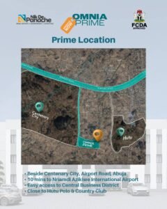
Omnia Prime Estate Abuja: The Complete Guide to Buying Land Beside Centenary City (2026) ABUJA · AIRPORT ROAD · CENTENARY CITY CORRIDOR
Omnia Prime Estate by Nik De Panache is a premium FCTA-approved development beside Centenary City on Airport Road, Abuja. This guide covers location, pricing, legal title, infrastructure, and investment potential, helping buyers understand how to secure land in one of Abuja’s fastest-growing corridors in 2026.

How to Buy Land in Abuja: A Simple Guide to a Safe Investment in 2026
A complete 2026 guide on how to buy land in Abuja safely, including legal steps, AGIS verification, required documents, scam prevention, and investment tips.